
Headed to Portland State University in Portland, Oregon this fall, but don’t know your way around campus? Or, headed back to PSU and looking for a better way to find what you’re looking for on campus? Don’t worry. You’re covered!
The Gartrell Group recently finished work on, and released, 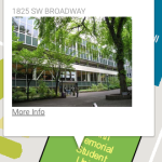 Version 1 of the PSU Campus Map. It’s a responsively designed site, so it can be used on your mobile device as well as your laptop or desktop computer.
Everything you need
When you open the map, by default, every building on campus is highlightable. Click on the building to find out the name, see a picture and have the option to dig deeper.
The powerful search engine uses autocomplete to help you quickly find what you are looking for, from specific rooms to departments, or even administrative offices.
Themed Maps
 In addition to the search function, there are theme maps that help you quickly find what you are looking for. Since transportation to and from school is pretty important, the Transit and Parking maps are at the
top. Included are all of the MAX (light rail), Streetcar and Bus stops. Click the icon on the map to see links to arrival times.
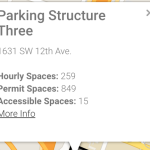
If you need to park on campus, there are two options within the Parking map; Hourly/Daily and Permit. When you turn either, or both (you can turn on every theme map, if you want, but the map may get a bit crowded!) parking maps on, the lots on the map are highlighted. Click on one to get more information about it.
Food is also a pretty important thing to a hard-working college student. The map has three food-related layers; restaurants, coffee shops, and food carts (because, 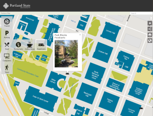 Portland).
While most people on campus have a laptop these days, not everyone has a printer in their dorm room or apartment. The Computers layer of the map shows the location of all of the campus computer labs, where, probably of more importance than the actual computers, there are printers located for student use.
Also included are a variety of campus tours. The PSU Campus tour map highlights important features on  campus, from the recreation center to the campus bookstore. The Art tour map is a guide to PSU’s large collection of sculptures, paintings and other art installations. From LEED buildings to bioswales, a cycle track to a field made from recycled sneakers, the Sustainability tour puts PSU’s leadership in urban sustainability on the map. Literally.
Share it!
What modern app would be complete without a share option? With the PSU Campus Map, the share option is always present. It’s easy to quickly grab the URL of the map view that you are looking at and email it, Facebook it, Twitter it, Yik Yak it – the list is long, the point is simple; you can share whatever you are looking at on the map with whomever you’d like, however you’d like.
Tech details
PSU needed a map that was easy to maintain and update and ideally did not require a specialized map server to deliver their map data. After analyzing PSU’s needs, The Gartrell Group designed the solution around an AngularJS-based web application using the Google Maps API. The colored campus overlay is stored in a geographic tile cache of images on an Apache Web Server while the data for the buildings, parking lots and transportation information are stored in geoJSON files on the server.
GeoJSON is a format for encoding geographic data within JSON formatted text files. Because of the tile cache and geoJSON files, no specialized map server is required and any web server can be used for this solution. When PSU wants to update the map, they simply replace the tile cache or the geoJSON files. PSU generates the tile cache and geoJSON files using standard GIS tools.