disaster planning

Stormwater Modeling for better Asset Management

We’ve spent much of 2016 working on a stormwater modeling project with the folks at DHI for the City of Portland, Oregon’s Bureau of Environmental Services (BES). The project, known as the the Stormwater System Plan (SWSP), will ultimately provide BES with best management practice strategies for stormwater assets, and is – forgive the pun – groundbreaking.

Replacing aging infrastructure

Stormwater modeling can help reduce localized flooding.Stormwater runoff is not the most sexy thing, and generally does not get a great deal of attention by the public, but it can be an incredibly destructive force to reckon with. Knowing ahead of time where there are risks can help mitigate those risks, and, quite possibly avoid the destruction of property. Much of the infrastructure that we depend upon is nearing, or well past, its end-of-life (EOL, as the engineers like to say). Stormwater modeling helps give engineers a better understanding of the weakest points in the system.

The last time this nation saw major infrastructure work was during the Eisenhower administration! Considering the fact that people who were born then are now retiring, now is a good time to turn our attention to the physical parts of our cities that are of the same age. This project will help BES to make more educated decisions when it comes to replacing or maintaining the assets that they are responsible for. When you think about it, these assets are a crucial part of modern life.

Understanding risks

BES is looking to have a better understanding of the risks associated with stormwater runoff in the cases of:

  • Sanitary sewage releases – when untreated sewage is discharged from a sanitary sewer into the environment prior to reaching sewage treatment facilities. Portland’s Big Pipe project a few years ago helped minimize these events, but did not stop them entirely.
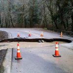
  • Landslide hazards – this can range from small rockfall events to entire hillsides giving away. Having a better understanding of this problem can save lives and prevent property loss.
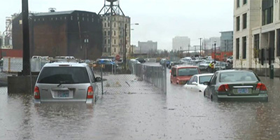
  • Localized nuisance flooding – how to control low area flooding. Flooded basements are no fun for anyone!
  • Loss of habitat – how does the local animal life contribute to controlling (or disrupting) stormwater runoff?
  • Disruption to hydrologic cycle – this includes looking at how removing (or adding) vegetation impacts the water cycle.
  • Approvable routes of conveyance – these are routes that property owners can use to dispose of stormwater that builds up on their property.

Stormwater modeling can help reduce washoutsBuilding python scripts

Our role in the project has been to assist in the scripting and geoprocessing of the risk categories listed above. These scripts will help BES to run advanced models of stormwater runoff in order to help identify areas where assets are either nonexistent – and may possibly be needed - or present but in need of attention in some way. This can help focus the often expensive work. It’s important to have a way to prioritize the efforts and appropriately target investments where infrastructure is lacking, in most dire need of repair or replacement, or where considerations such as social equity or development and population dynamics call for it.


The time to make a plan is now

emergency-response21-223491Reality: Emergencies happen

Contemplating worst case scenarios and one’s potential responses is clearly a source of amusement for many. But to public servants who shoulder the responsibility of providing critical services to citizens in a time of crisis, considering the ramifications of different types of emergencies can be a very sobering thing indeed.

Earthquakes, hazardous chemicals, disrupted transportation infrastructure, criminal sabotage, housebound staff, islands of isolation…little creativity is required to conjure visions of circumstances within which maintaining basic services and providing vital support to citizens can abruptly change from daily and routine to supremely challenging.

Preparation is key.

Preparing to Prepare

washWe are working with Washington County, Oregon to help assess their needs and optimize their resources so they are better equipped to plan responses to different types of emergencies. The project involves a broad group of stakeholders that extends across many County departments.

We’ll start by examining individual and shared needs and concerns to help define the ideal type of information needed in a variety of emergencies. Next, we’ll explore the best way to provide that information so that stakeholders may individually and collectively improve their planning and preparation for responding in times of crisis.

After we’ve spoken to shareholders, defined the necessary information, and explored options for sharing that information when the resources we take for granted on a daily basis have been compromised, we’ll provide recommended solutions and help the County in implementing them.

Common Functions

The necessary information needed by this particular set of shareholders will certainly be unique, but in our experience with helping organizations prepare for emergencies, we’ve found that the solutions start with many commonalities:

  • They need to address geographic, place-based questions.
  • They must cross functional, operational, and jurisdictional boundaries. Disasters tend not to honor human boundaries!
  • They must be multi-disciplinary.
  • A planning and training module is extremely important. The best way provide a truly coordinated response is continual training. Part of good planning involves assuring that emergency responders have “muscle memory” when it comes to their tools so there are no questions about how to use them.

Preparation Saves Lives!

No one wants a disaster to occur, but when they do happen, preparation can save lives. A solid plan, and useful tools can be the difference between a smooth recovery and a long haul.

If it’s time to assess your emergency preparedness and planning resources, feel free to drop us a line.

Disaster Relief Planning. We've got your back.

Superstorm Sandy has, for good reasons, dominated the national attention over the past few weeks. No one wants to find themselves in the midst of a disaster, but, unfortunately, disasters do occur. And when they DO happen, we want to be sure that our federal, state, and local officials are ready.
At the Gartrell Group, one of our specialties is helping those that plan for disaster relief be better prepared. Our practical, on-the-ground experience providing mapping support in the wake of major hurricanes, tsunamis, and other natural and human-caused disasters and crises has taught us to value the benefit of planning and the importance of having the right tools to do it.

Recent project work in Disaster Relief Planning…

Some of our recent project work has included helping the Oregon Office of Emergency Management (OEM) design and implement a contemporary Geographical Information System (GIS) with the goal of improving the agency’s spatial intelligence in tracking and managing the response to emergency incidents.   Call center operators working with OEM’s “Ops Center” incident tracking system now have a flexible set of capabilities to record geographic details associated with incidents. These improvements allow for entering, viewing, analyzing, and updating incident information through a simple map interface; they also allow OEM to share their incident data as a web service with partners in the emergency response community. The value and critical importance of cross-platform and cross-agency data sharing is close to the heart of anyone who has been involved in decision support in the midst of disaster. OEM intends that these changes will help them to fulfill their mission of “coordinating and facilitating emergency planning, preparedness, and response activities with the state and local emergency services agencies”.

We have also been working closely with the emergency management and GIS team at Multnomah County, Oregon for over a year to design and develop their enterprise emergency planning and response system, called “Bridge”. Bridge is a situational awareness mapping product that gives emergency responders a flexible toolbox for managing and analyzing information related to a wide array of incidents and emergencies. Using Bridge, managers and responders have the ability to select data from a catalog and rapidly configure a series of interactive maps suitable to the requirements and questions of a particular event or scenario; they can easily switch between area views to ‘zoomed-in’ location specific views as needs dictate.   In addition to working with well-described data that is included in the Bridge Data Catalog, users may also dynamically load other data (including secured web services) that may be provided by partners or retrieved from the data sphere when an unanticipated need or question arises.  Bridge also includes tools for indentifying critical infrastructure, vulnerable populations, or other resources of interest that may fall within a particular response zone, area of concern, or within a defined distance to an incident location.

Not only does Bridge help responders deal with emergencies as they happen, but it can help event planners visualize the impact of their event on a community well before their event. The tool allows responders and planners to save and share events, so they can plan for that parade, or are ready when a water main has flooded a street.   A simplified mobile version of the application has also been developed for use on smartphones and tablet devices.

The team at Multnomah County has done an exemplary job of engaging with their partners and stakeholders in the emergency management community through the design and development of Bridge — it is very much a reflection of the expressed needs, preferences, and desires of this group, which helps explain its steadily increasing number of partners and subscribers.  The Bridge subscriber community now includes officials from public agencies, fire departments, and schools, as well as staff from hospitals, utilities, and private companies in the greater Portland, OR area.

Geospatial tools and the operational support they offer are fundamentally important to:

  • Information sharing and communication;
  • Response planning, management, and coordination;
  • Vehicle, personnel, and asset dispatch, allocation, and tracking;
  • Field assessment and reporting;
  • Damage calculations;
  • Business continuity planning;
  • Scenario modeling and predictive analytics;
  • Portfolio risk management, asset exposure analysis.


For more information about how we might help you be better prepared, or to see a demo, please contact contact us.