


Monitor this channel for more on cool new mapping resources brought to you by the Washington Department of Parks & Rec.

![]() Continuing our long collaboration with the City of Tigard, we have recently begun a new consultation project focused on helping the City envision and define their next generation GIS architecture. The goal is to equip Tigard for growing geospatial demands while simplifying the upkeep and maintenance of their resources so that they are easily maintainable by current staff.
Continuing our long collaboration with the City of Tigard, we have recently begun a new consultation project focused on helping the City envision and define their next generation GIS architecture. The goal is to equip Tigard for growing geospatial demands while simplifying the upkeep and maintenance of their resources so that they are easily maintainable by current staff.
That’s no small task, when you think about it. Location data is growing in importance for both government and industry, as well as individuals. GIS used to be it’s own separate fiefdom within most organizations. Something that was a secondary concern compared to other IT needs. But now GIS data is being being folded into everyday workflows and applications.
So how do we simplify a process that seems to be ever-growing in complexity? For starters, we do our homework. We look closely at the City’s current architecture and the workflows it supports; we look at the maintenance effort and procedures require to sustain the current system; we review the needs of different stakeholder and end user groups. With information gathered from these activities, we are able to accurately characterize the current state of operations, complete with areas of risk, and areas where changes, expansions, and improvements are most desired. We can then combine some industry research and peer review information with our own experience working with many other organizations to optimize their geospatial systems to develop a responsive set of recommendations for Tigard’s next generation GIS platform.
Some of the factors to be addressed through completion of this project include:
We’ve spent much of 2016 working on a stormwater modeling project with the folks at DHI for the City of Portland, Oregon’s Bureau of Environmental Services (BES). The project, known as the the Stormwater System Plan (SWSP), will ultimately provide BES with best management practice strategies for stormwater assets, and is – forgive the pun – groundbreaking.
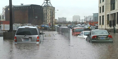 Stormwater runoff is not the most sexy thing, and generally does not get a great deal of attention by the public, but it can be an incredibly destructive force to reckon with. Knowing ahead of time where there are risks can help mitigate those risks, and, quite possibly avoid the destruction of property. Much of the infrastructure that we depend upon is nearing, or well past, its end-of-life (EOL, as the engineers like to say). Stormwater modeling helps give engineers a better understanding of the weakest points in the system.
The last time this nation saw major infrastructure work was during the Eisenhower administration! Considering the fact that people who were born then are now retiring, now is a good time to turn our attention to the physical parts of our cities that are of the same age. This project will help BES to make more educated decisions when it comes to replacing or maintaining the assets that they are responsible for. When you think about it, these assets are a crucial part of modern life.
BES is looking to have a better understanding of the risks associated with stormwater runoff in the cases of:
 Building python scripts
Our role in the project has been to assist in the scripting and geoprocessing of the risk categories listed above. These scripts will help BES to run advanced models of stormwater runoff in order to help identify areas where assets are either nonexistent – and may possibly be needed - or present but in need of attention in some way. This can help focus the often expensive work. It’s important to have a way to prioritize the efforts and appropriately target investments where infrastructure is lacking, in most dire need of repair or replacement, or where considerations such as social equity or development and population dynamics call for it.